


A Tornado Watch is in effect until 1 AM for Colbert, Franklin and Lauderdale Counties.
Dangerous storms are expected to impact North Alabama tonight. Here are the latest timelines and threats for each region.
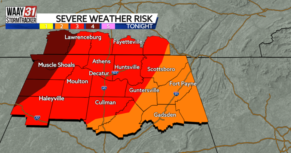
Shoals: Timing – 12 AM this evening to 3 AM Saturday. Threats – Tornadoes (some strong), wind gusts up to 75 MPH, large hail, and flash flooding.
I-65 Corridor & Huntsville: Timing – 2 AM to 5 AM Saturday. Threats – Tornadoes, wind gusts up to 70 MPH, and flash flooding.
Sand Mountain: Timing: 3 AM to 6 AM Saturday. Threats – Brief tornadoes and wind gusts up to 60 MPH.
Just like last Friday night, tornadoes could rapidly develop tonight without much warning. Be prepared to take quick action. Strong tornadoes will be also possible tonight, especially west of I-65.
We cannot emphasize enough the importance of having multiple ways to get warnings overnight while most of you are sleeping.
Even when it isn’t storming, it will be windy with gusts up to 45 mph possible. A Wind Advisory is in effect from 4 PM today through 1 PM Saturday.
The weekend will be much quieter. Sunny skies Saturday and Sunday push our high temperatures into the upper 60s to mid 70s. Multiple rounds of showers and storms will return next week.
TONIGHT: Strong storms, some severe. Lows in the low 60s. Chance of rain: 100%. Wind: SSW 15-30 MPH, gusting to 45 MPH.
SATURDAY: Mostly sunny and windy. Highs in the mid 70s. Wind: WNW 12-22 MPH, gusting up to 40 MPH.
Source : WAAYTV